Title:
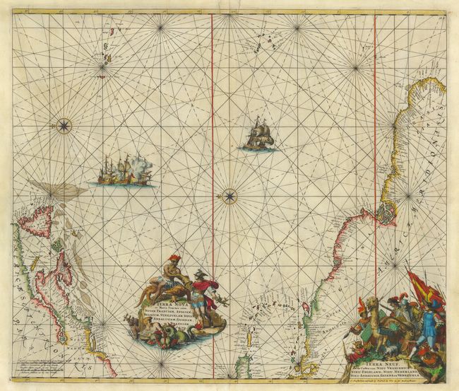
“Terra Nova, ac Maris Tractus circa Novam Franciam, Angliam, Belgium, Venezuelam Novam Andalusiam, Guianam et Brasiliam - Terra Neuf, en de Custen van Nieu Vranckryck, Nieu Engeland, Nieu Nederland, Nieu Andalusia, Guiana en Venezuela”
Map Maker:
Frederick de Wit
Magnificent sea chart of the western Atlantic Ocea... (full text available to subscribers)
| Item Detail |
| |
| |
MapMaker: |
Frederick de Wit
|
|
| |
| |
Subject: |
Atlantic Ocean |
|
| |
Period/Size: |
1680 / 19.0" x 22.2" (48.3 x 56.4 cm)
|
|
| |
Color: |
Colored
|
|
| |
Condition: |
(B) Nice impression and color. Repaired tears at the top, just entering map, on either side of the centerfold. Hinge remnants on verso, couple small chips in lower, blank margin. (condition help) |
|
| |
Source: |
Orbis Maritimus ofte Zee Atlas |
|
| |
References: |
|
|
| |
|
|
| Sales Information |
| |
| |
Price: |
|
|
| |
| |
Offered by: |
Old World Auctions |
|
| |
Catalog: |
Auction No. 118 - Antique Maps, Charts, Atlases & Globes (584) |
|
| |
Lot/Item #: |
509 |
|
| |
| |
Date: |
03/2007
|
|
| |
| |
|
Antique Maps - Valuation and Pricing, Descriptions, Resources |
|
Home |
Information |
Search |
Register |
Contact Us |
Site Map
Americana Exchange, Inc. © 1999 - 2024 Americana Exchange, Inc.. All rights reserved.
OldMaps.com, the OldMaps.com logo and
AMPR are service marks or registered service marks of Americana Exchange, Inc..
|