Title:
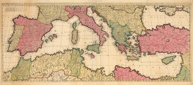
“Mare Mediterraneum , exhibins oras Hispaniae, Galliae, Italiae, Mare Hadriaticum, Archipeligus, Natoliam, Aegyptum…”
Map Maker:
Valk [Family]
Striking, large map of the Mediterranean on two jo... (full text available to subscribers)
| Item Detail |
| |
| |
MapMaker: |
Valk [Family]
|
|
| |
| |
Subject: |
Mediterranean |
|
| |
Period/Size: |
1700 / 19.0" x 45.5" (48.3 x 115.6 cm)
|
|
| |
Color: |
Colored
|
|
| |
Condition: |
(B) Original color and nice impression. Repaired tear in upper left margin, 1.5 inches into map. Some irregular toning and some soft creases at the edges. Verdigris oxidation on Ibiza has caused a small spot of loss. (condition help) |
|
| |
Source: |
|
|
| |
References: |
|
|
| |
|
|
| Sales Information |
| |
| |
Price: |
|
|
| |
| |
Offered by: |
Old World Auctions |
|
| |
Catalog: |
Auction No. 118 - Antique Maps, Charts, Atlases & Globes (584) |
|
| |
Lot/Item #: |
747 |
|
| |
| |
Date: |
03/2007
|
|
| |
| |
|
Antique Maps - Valuation and Pricing, Descriptions, Resources |
|
Home |
Information |
Search |
Register |
Contact Us |
Site Map
Americana Exchange, Inc. © 1999 - 2024 Americana Exchange, Inc.. All rights reserved.
OldMaps.com, the OldMaps.com logo and
AMPR are service marks or registered service marks of Americana Exchange, Inc..
|