Title:
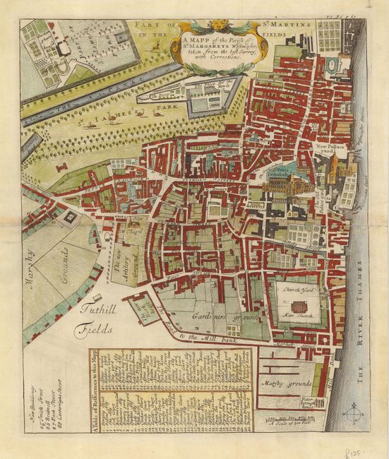
“A Mapp of the Parish of St. Margarets Westminster, taken from the last Survey, with Corrections.”
Map Maker:
John Strype
This is the first detailed ward map of Westminster... (full text available to subscribers)
| Item Detail |
| |
| |
MapMaker: |
John Strype
|
|
| |
| |
Subject: |
England |
|
| |
Period/Size: |
1720 / 13.8" x 11.6" (35.1 x 29.5 cm)
|
|
| |
Color: |
Colored
|
|
| |
Condition: |
(B) Centerfold reinforced with paper on verso with slight toning on fold. Some pencil marking in blank margins. (condition help) |
|
| |
Source: |
Stow's Survey of London |
|
| |
References: |
|
|
| |
|
|
| Sales Information |
| |
| |
Price: |
|
|
| |
| |
Offered by: |
Old World Auctions |
|
| |
Catalog: |
Auction No. 118 - Antique Maps, Charts, Atlases & Globes (584) |
|
| |
Lot/Item #: |
551 |
|
| |
| |
Date: |
03/2007
|
|
| |
| |
|
Antique Maps - Valuation and Pricing, Descriptions, Resources |
|
Home |
Information |
Search |
Register |
Contact Us |
Site Map
Americana Exchange, Inc. © 1999 - 2024 Americana Exchange, Inc.. All rights reserved.
OldMaps.com, the OldMaps.com logo and
AMPR are service marks or registered service marks of Americana Exchange, Inc..
|