Title:
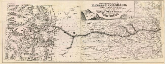
“A Geographically Correct Map of Kansas & Colorado, Showing Principal Cities & Towns…Reached by the Kansa Pacific Railway, the "Golden Belt Route"”
Map Maker:
Railroad Companies
This is a very scarce, ephemeral railroad map illu... (full text available to subscribers)
| Item Detail |
| |
| |
MapMaker: |
Railroad Companies
|
|
| |
| |
Subject: |
Colorado and Kansas |
|
| |
Period/Size: |
1878 / 9.8" x 25.0" (24.9 x 63.5 cm)
|
|
| |
Color: |
Black & White
|
|
| |
Condition: |
(B) Issued folding now pressed. Couple of abrasions in map affecting Rice and Lincoln Counties in Kansas. Couple of light tissue repairs on verso. (condition help) |
|
| |
Source: |
|
|
| |
References: |
|
|
| |
|
|
| Sales Information |
| |
| |
Price: |
|
|
| |
| |
Offered by: |
Old World Auctions |
|
| |
Catalog: |
Auction No. 118 - Antique Maps, Charts, Atlases & Globes (584) |
|
| |
Lot/Item #: |
323 |
|
| |
| |
Date: |
03/2007
|
|
| |
| |
|
Antique Maps - Valuation and Pricing, Descriptions, Resources |
|
Home |
Information |
Search |
Register |
Contact Us |
Site Map
Americana Exchange, Inc. © 1999 - 2024 Americana Exchange, Inc.. All rights reserved.
OldMaps.com, the OldMaps.com logo and
AMPR are service marks or registered service marks of Americana Exchange, Inc..
|