Title:
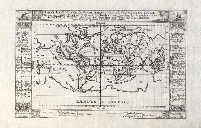
“Carta Hydrographica oder Algemeine Welt und Commercien Carte Warinnen die Grosse Meer und Seen auch See Kusten, und fornehmbs te Laender, der Gantzen Welt, neben denen Schiffarthen nach West uud Oost Indien auch von dar Zurucke deutlich entworffen”
Map Maker:
Stridbeck/Bodenehr
An uncommon world map that shows the Dutch commerc... (full text available to subscribers)
| Item Detail |
| |
| |
MapMaker: |
Stridbeck/Bodenehr
|
|
| |
| |
Subject: |
World |
|
| |
Period/Size: |
1730 / 5.9" x 9.1" (15.0 x 23.2 cm)
|
|
| |
Color: |
Black & White
|
|
| |
Condition: |
(A) Dark impression with full margins on hand laid paper with a large watermark. One small rust spot near the Caspian Sea, still very good. The map image is printed slightly askew to the paper. (condition help) |
|
| |
Source: |
|
|
| |
References: |
|
|
| |
|
|
| Sales Information |
| |
| |
Price: |
|
|
| |
| |
Offered by: |
Old World Auctions |
|
| |
Catalog: |
Auction No. 118 - Antique Maps, Charts, Atlases & Globes (584) |
|
| |
Lot/Item #: |
038 |
|
| |
| |
Date: |
03/2007
|
|
| |
| |
|
Antique Maps - Valuation and Pricing, Descriptions, Resources |
|
Home |
Information |
Search |
Register |
Contact Us |
Site Map
Americana Exchange, Inc. © 1999 - 2024 Americana Exchange, Inc.. All rights reserved.
OldMaps.com, the OldMaps.com logo and
AMPR are service marks or registered service marks of Americana Exchange, Inc..
|