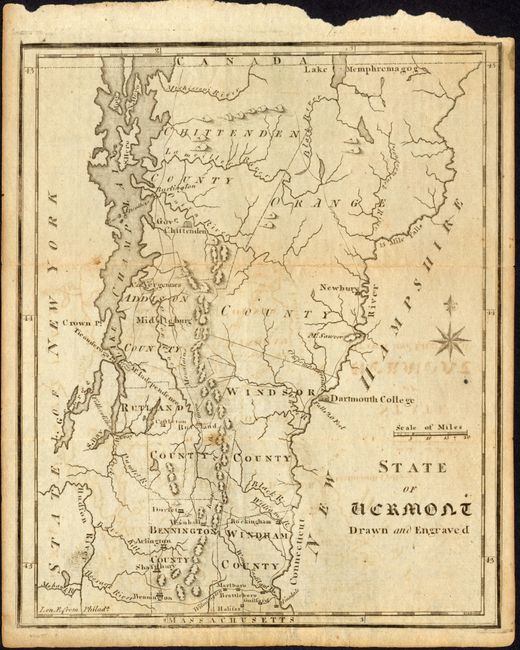
Title:
“State of Vermont Drawn and Engraved”
Map Maker:
Joseph T. Scott
This is a terrific example of an American-produced... (full text available to subscribers)
| Item Detail |
| |
| |
MapMaker: |
Joseph T. Scott
|
|
| |
| |
Subject: |
Vermont |
|
| |
Period/Size: |
1795 / 7.5" x 6.0" (19.1 x 15.3 cm)
|
|
| |
Color: |
Black & White
|
|
| |
Condition: |
(B) Issued folding. With some offsetting. Upper binding edge a little ragged and close to the neatline at the upper right corner. (condition help) |
|
| |
Source: |
United States Gazetteer |
|
| |
References: |
Wheat & Brun #196. |
|
| |
|
|
| Sales Information |
| |
| |
Price: |
|
|
| |
| |
Offered by: |
Old World Auctions |
|
| |
Catalog: |
Auction No. 119 - Antique Maps, Charts, Atlases & Globes (585) |
|
| |
Lot/Item #: |
355 |
|
| |
| |
Date: |
05/2007
|
|
| |
| |
|
Antique Maps - Valuation and Pricing, Descriptions, Resources |
|
Home |
Information |
Search |
Register |
Contact Us |
Site Map
Americana Exchange, Inc. © 1999 - 2024 Americana Exchange, Inc.. All rights reserved.
OldMaps.com, the OldMaps.com logo and
AMPR are service marks or registered service marks of Americana Exchange, Inc..
|