Title:
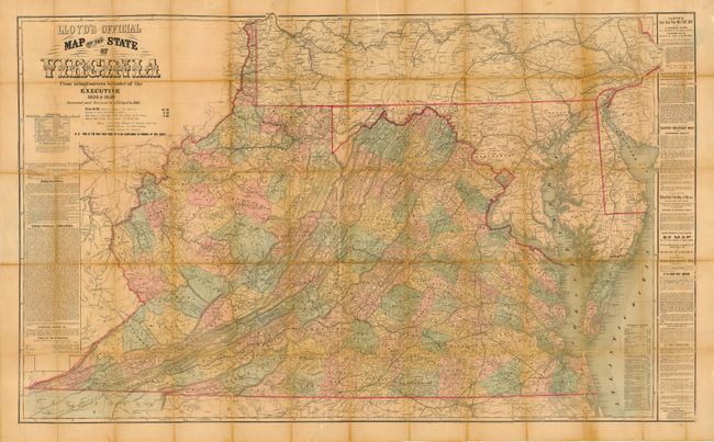
“Lloyd's Official Map of the State of Virginia from Actual Surveys by Order of the Executive 1828 & 1859, corrected and revised by J.T. Lloyd to 1861”
Map Maker:
James T. Lloyd
Scarce, large-scale dissected folding map of Virgi... (full text available to subscribers)
| Item Detail |
| |
| |
MapMaker: |
James T. Lloyd
|
|
| |
| |
Subject: |
Virginia |
|
| |
Period/Size: |
1861 / 30.3" x 47.3" (77.0 x 120.2 cm)
|
|
| |
Color: |
Colored
|
|
| |
Condition: |
(B) Dissected and linen backed, missing its covers. The map has some separations on the folds and a few areas of flaking and loss. There is some archival tape on the verso. (condition help) |
|
| |
Source: |
|
|
| |
References: |
Phillips (M) p. 988; Phillips (VA) p.72. |
|
| |
|
|
| Sales Information |
| |
| |
Price: |
|
|
| |
| |
Offered by: |
Old World Auctions |
|
| |
Catalog: |
Auction No. 119 - Antique Maps, Charts, Atlases & Globes (585) |
|
| |
Lot/Item #: |
359 |
|
| |
| |
Date: |
05/2007
|
|
| |
| |
|
Antique Maps - Valuation and Pricing, Descriptions, Resources |
|
Home |
Information |
Search |
Register |
Contact Us |
Site Map
Americana Exchange, Inc. © 1999 - 2024 Americana Exchange, Inc.. All rights reserved.
OldMaps.com, the OldMaps.com logo and
AMPR are service marks or registered service marks of Americana Exchange, Inc..
|