Title:
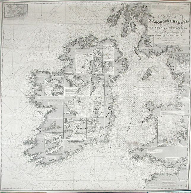
“A Chart of St. George's Channel and Coasts of Ireland, &c. Constructed & Drawn from the Latest Observations and Surveys”
Map Maker:
John Stratton Hobbs
Gorgeous blue-back sea chart of the coastal waters... (full text available to subscribers)
| Item Detail |
| |
| |
MapMaker: |
John Stratton Hobbs
|
|
| |
| |
Subject: |
Ireland |
|
| |
Period/Size: |
1882 / 49.5" x 47.5" (125.8 x 120.7 cm)
|
|
| |
Color: |
Black & White
|
|
| |
Condition: |
(A) This chart is in near fine condition for a working sea chart of this type. It has a few stains in Liverpool Bay and St. George's Channel, as well as a couple penciled navigational notes, but otherwise it is very sound and does not have any of the mar (condition help) |
|
| |
Source: |
|
|
| |
References: |
|
|
| |
|
|
| Sales Information |
| |
| |
Price: |
|
|
| |
| |
Offered by: |
Old World Auctions |
|
| |
Catalog: |
Auction No. 119 - Antique Maps, Charts, Atlases & Globes (585) |
|
| |
Lot/Item #: |
497 |
|
| |
| |
Date: |
05/2007
|
|
| |
| |
|
Antique Maps - Valuation and Pricing, Descriptions, Resources |
|
Home |
Information |
Search |
Register |
Contact Us |
Site Map
Americana Exchange, Inc. © 1999 - 2024 Americana Exchange, Inc.. All rights reserved.
OldMaps.com, the OldMaps.com logo and
AMPR are service marks or registered service marks of Americana Exchange, Inc..
|