Title:
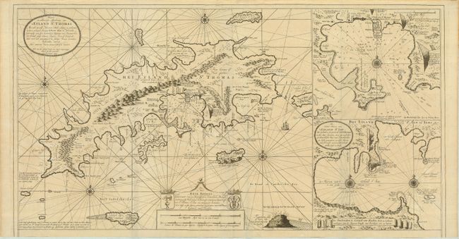
“Nieuwe en Aldereerste Afteekening van 't Eyland St. Thomas. Met alle desselfs Havenen, Anker Plaatse…”
Map Maker:
Gerard van Keulen
This magnificent large-scale chart is one of the e... (full text available to subscribers)
| Item Detail |
| |
| |
MapMaker: |
Gerard van Keulen
|
|
| |
| |
Subject: |
Virgin Islands |
|
| |
Period/Size: |
1719 / 20.5" x 39.0" (52.1 x 99.1 cm)
|
|
| |
Color: |
Black & White
|
|
| |
Condition: |
(B) The chart was original published with a series of coastal profiles along the bottom. This example has been trimmed at bottom leaving an ample margin. Clean, crisp impression printed on quality paper. (condition help) |
|
| |
Source: |
De Groote Nieuwe Vermeerderde Zee Atlas ofte Water-Waereld |
|
| |
References: |
|
|
| |
|
|
| Sales Information |
| |
| |
Price: |
|
|
| |
| |
Offered by: |
Old World Auctions |
|
| |
Catalog: |
Auction No. 119 - Antique Maps, Charts, Atlases & Globes (585) |
|
| |
Lot/Item #: |
417 |
|
| |
| |
Date: |
05/2007
|
|
| |
| |
|
Antique Maps - Valuation and Pricing, Descriptions, Resources |
|
Home |
Information |
Search |
Register |
Contact Us |
Site Map
Americana Exchange, Inc. © 1999 - 2024 Americana Exchange, Inc.. All rights reserved.
OldMaps.com, the OldMaps.com logo and
AMPR are service marks or registered service marks of Americana Exchange, Inc..
|