Title:
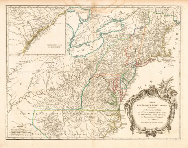
“Partie de l'Amerique Septentrionale, qui Comprend le Cours de l'Ohio, la Nlle Angleterre, la Nlle York, le New Jersey, la Pensylvanie, la Maryland, la Virginie, la Caroline”
Map Maker:
Didier Robert de Vaugondy
Beautifully engraved, large map of the eastern sea... (full text available to subscribers)
| Item Detail |
| |
| |
MapMaker: |
Didier Robert de Vaugondy
|
|
| |
| |
Subject: |
Colonial United States |
|
| |
Period/Size: |
1768 / 18.8" x 24.5" (47.8 x 62.3 cm)
|
|
| |
Color: |
Colored
|
|
| |
Condition: |
(B) Original outline color. Damp stain in upper center margin extending about 1" into map. There is a tear in the lower left margin that has been repaired with archival tissue on the verso. (condition help) |
|
| |
Source: |
|
|
| |
References: |
Cumming (SE) #295; McCorkle #755-37; Pedley #469; Sellers & Van Eel #718. |
|
| |
|
|
| Sales Information |
| |
| |
Price: |
|
|
| |
| |
Offered by: |
Old World Auctions |
|
| |
Catalog: |
Auction No. 121 - Antique Maps, Charts, Atlases & Globes (614) |
|
| |
Lot/Item #: |
153 |
|
| |
| |
Date: |
09/2007
|
|
| |
| |
|
Antique Maps - Valuation and Pricing, Descriptions, Resources |
|
Home |
Information |
Search |
Register |
Contact Us |
Site Map
Americana Exchange, Inc. © 1999 - 2024 Americana Exchange, Inc.. All rights reserved.
OldMaps.com, the OldMaps.com logo and
AMPR are service marks or registered service marks of Americana Exchange, Inc..
|