Title:
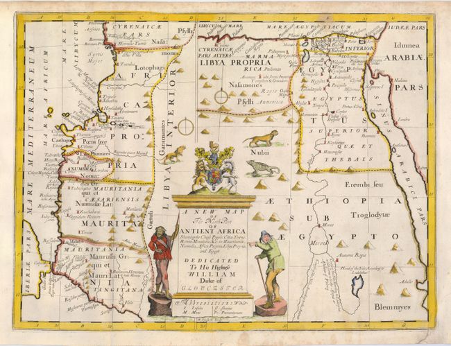
“A New Map of the North Part of Antient Africa Shewing the Chiefe People, Cities, Towns, Rivers, Mountains &c. in Mauritania, Numidia, Africa Propria, Libya Propria, and Egypt”
Map Maker:
Edward Wells
This is a most unusual and interesting map with an... (full text available to subscribers)
| Item Detail |
| |
| |
MapMaker: |
Edward Wells
|
|
| |
| |
Subject: |
Africa - Northern |
|
| |
Period/Size: |
1700 / 14.3" x 19.2" (36.4 x 48.8 cm)
|
|
| |
Color: |
Colored
|
|
| |
Condition: |
(B) Lovely impression and attractive color. Bottom corner with tear into border of map, repaired with archival tissue. Some irregular foxing in the margin has encroached a little into the map. (condition help) |
|
| |
Source: |
New Sett of Maps both Ancient and Present Geography |
|
| |
References: |
|
|
| |
|
|
| Sales Information |
| |
| |
Price: |
|
|
| |
| |
Offered by: |
Old World Auctions |
|
| |
Catalog: |
Auction No. 121 - Antique Maps, Charts, Atlases & Globes (614) |
|
| |
Lot/Item #: |
777 |
|
| |
| |
Date: |
09/2007
|
|
| |
| |
|
Antique Maps - Valuation and Pricing, Descriptions, Resources |
|
Home |
Information |
Search |
Register |
Contact Us |
Site Map
Americana Exchange, Inc. © 1999 - 2024 Americana Exchange, Inc.. All rights reserved.
OldMaps.com, the OldMaps.com logo and
AMPR are service marks or registered service marks of Americana Exchange, Inc..
|