Title:
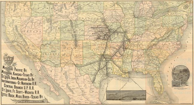
“Map of the Missouri Pacific Ry, Missouri, Kansas and Texas Ry. St Louis, Iron Mountain and So. Ry. International and Gt. Northern R.R. Central Branch U.P.R.R. St. Louis, Ft. Scott and Wichita R.R. Little Rock, Miss. River and Texas Ry. And Connections.”
Map Maker:
Rand, McNally & Co.
This is a folding map and timetable for the Missou... (full text available to subscribers)
| Item Detail |
| |
| |
MapMaker: |
Rand, McNally & Co.
|
|
| |
| |
Subject: |
United States |
|
| |
Period/Size: |
1887 / 16.8" x 31.0" (42.7 x 78.8 cm)
|
|
| |
Color: |
Colored
|
|
| |
Condition: |
(A) This is a lovely example that is in near fine condition. A couple very small fold intersection splits and one area of roughness at border. (condition help) |
|
| |
Source: |
|
|
| |
References: |
|
|
| |
|
|
| Sales Information |
| |
| |
Price: |
|
|
| |
| |
Offered by: |
Old World Auctions |
|
| |
Catalog: |
Auction No. 120 - Antique Maps, Charts, Atlases & Globes (613) |
|
| |
Lot/Item #: |
169 |
|
| |
| |
Date: |
07/2007
|
|
| |
| |
|
Antique Maps - Valuation and Pricing, Descriptions, Resources |
|
Home |
Information |
Search |
Register |
Contact Us |
Site Map
Americana Exchange, Inc. © 1999 - 2024 Americana Exchange, Inc.. All rights reserved.
OldMaps.com, the OldMaps.com logo and
AMPR are service marks or registered service marks of Americana Exchange, Inc..
|