Title:
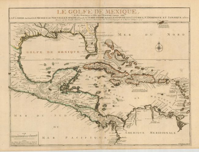
“Le Golfe de Mexique, et les Provinces et Isles qui l'Environe comme sont la Floride au Nord, le Mexique ou Nouvelle Espagne a l'Ouest, la Terre-Ferme au Sud, les Is. Antilles, Lucayes, St. Domingue et Jamaique a l'Est…”
Map Maker:
Nicolas de Fer
This is scarce map of the Gulf of Mexico and the C... (full text available to subscribers)
| Item Detail |
| |
| |
MapMaker: |
Nicolas de Fer
|
|
| |
| |
Subject: |
Gulf of Mexico and Caribbean |
|
| |
Period/Size: |
1717 / 18.0" x 23.8" (45.8 x 60.5 cm)
|
|
| |
Color: |
Colored
|
|
| |
Condition: |
(B) Dark impression. Light damp stain along the centerfold with tissue reinforcing on the verso. A few light spots of foxing and two tiny, repaired wormholes. (condition help) |
|
| |
Source: |
|
|
| |
References: |
Lowery #281. |
|
| |
|
|
| Sales Information |
| |
| |
Price: |
|
|
| |
| |
Offered by: |
Old World Auctions |
|
| |
Catalog: |
Auction No. 120 - Antique Maps, Charts, Atlases & Globes (613) |
|
| |
Lot/Item #: |
368 |
|
| |
| |
Date: |
07/2007
|
|
| |
| |
|
Antique Maps - Valuation and Pricing, Descriptions, Resources |
|
Home |
Information |
Search |
Register |
Contact Us |
Site Map
Americana Exchange, Inc. © 1999 - 2024 Americana Exchange, Inc.. All rights reserved.
OldMaps.com, the OldMaps.com logo and
AMPR are service marks or registered service marks of Americana Exchange, Inc..
|