Title:
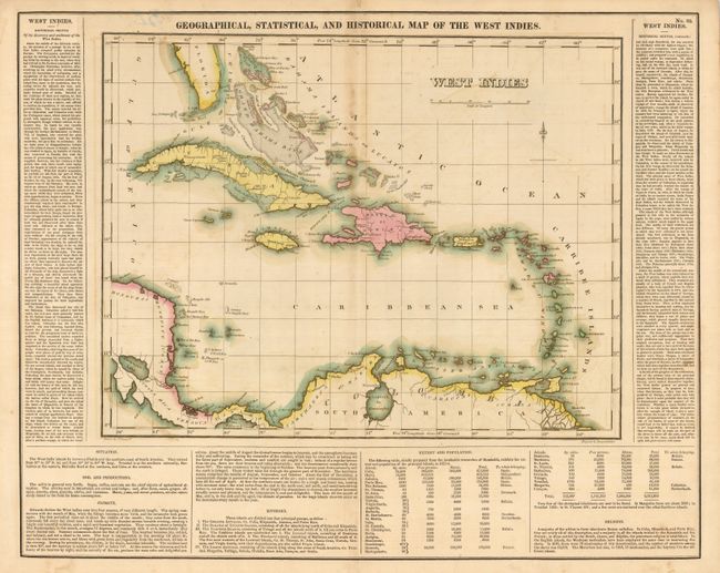
“Geographical, Statistical, and Historical Map of the West Indies”
Map Maker:
Carey & Lea
An attractive, richly colored map of the islands i... (full text available to subscribers)
| Item Detail |
| |
| |
MapMaker: |
Carey & Lea
|
|
| |
| |
Subject: |
Caribbean |
|
| |
Period/Size: |
1825 / 12.3" x 15.8" (31.2 x 40.0 cm)
|
|
| |
Color: |
Colored
|
|
| |
Condition: |
(B) Toning along top of centerfold and a little offsetting or toning around islands. Tape remnants and pen on verso with one small area of show through to front above map. (condition help) |
|
| |
Source: |
|
|
| |
References: |
|
|
| |
|
|
| Sales Information |
| |
| |
Price: |
|
|
| |
| |
Offered by: |
Old World Auctions |
|
| |
Catalog: |
Auction No. 120 - Antique Maps, Charts, Atlases & Globes (613) |
|
| |
Lot/Item #: |
380 |
|
| |
| |
Date: |
07/2007
|
|
| |
| |
|
Antique Maps - Valuation and Pricing, Descriptions, Resources |
|
Home |
Information |
Search |
Register |
Contact Us |
Site Map
Americana Exchange, Inc. © 1999 - 2024 Americana Exchange, Inc.. All rights reserved.
OldMaps.com, the OldMaps.com logo and
AMPR are service marks or registered service marks of Americana Exchange, Inc..
|