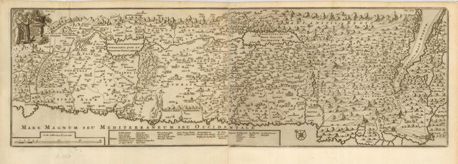
Title:
“Tabula Geographica Terrae Sanctae”
Map Maker:
Francois Halma
Uncommon map of Israel by the Flemish theologian J... (full text available to subscribers)
| Item Detail |
| |
| |
MapMaker: |
Francois Halma
|
|
| |
| |
Subject: |
Holy Land |
|
| |
Period/Size: |
1709 / 8.3" x 26.0" (21.0 x 66.1 cm)
|
|
| |
Color: |
Black & White
|
|
| |
Condition: |
(A) Superb impression with light marginal toning. Lower margin uneven as issued. (condition help) |
|
| |
Source: |
|
|
| |
References: |
Poortman & Augusteijn #167. |
|
| |
|
|
| Sales Information |
| |
| |
Price: |
|
|
| |
| |
Offered by: |
Old World Auctions |
|
| |
Catalog: |
Auction No. 121 - Antique Maps, Charts, Atlases & Globes (614) |
|
| |
Lot/Item #: |
722 |
|
| |
| |
Date: |
09/2007
|
|
| |
| |
|
Antique Maps - Valuation and Pricing, Descriptions, Resources |
|
Home |
Information |
Search |
Register |
Contact Us |
Site Map
Americana Exchange, Inc. © 1999 - 2024 Americana Exchange, Inc.. All rights reserved.
OldMaps.com, the OldMaps.com logo and
AMPR are service marks or registered service marks of Americana Exchange, Inc..
|