Title:
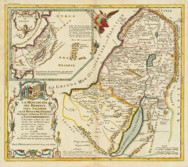
“La Monarchie des Hebreux sous Salomon ou de Roiaume d'Israel distrinque en Douze Prefectures ou Gouvernments…”
Map Maker:
Pierre Moullart-Sanson
This scarce map depicts the Holy Land as it was du... (full text available to subscribers)
| Item Detail |
| |
| |
MapMaker: |
Pierre Moullart-Sanson
|
|
| |
| |
Subject: |
Holy Land |
|
| |
Period/Size: |
1717 / 13.8" x 15.9" (35.0 x 40.4 cm)
|
|
| |
Color: |
Colored
|
|
| |
Condition: |
(+B) Sharp impression and attractive old color with faint toning along centerfold. (condition help) |
|
| |
Source: |
|
|
| |
References: |
Laor #512. |
|
| |
|
|
| Sales Information |
| |
| |
Price: |
|
|
| |
| |
Offered by: |
Old World Auctions |
|
| |
Catalog: |
Auction No. 121 - Antique Maps, Charts, Atlases & Globes (614) |
|
| |
Lot/Item #: |
724 |
|
| |
| |
Date: |
09/2007
|
|
| |
| |
|
Antique Maps - Valuation and Pricing, Descriptions, Resources |
|
Home |
Information |
Search |
Register |
Contact Us |
Site Map
Americana Exchange, Inc. © 1999 - 2024 Americana Exchange, Inc.. All rights reserved.
OldMaps.com, the OldMaps.com logo and
AMPR are service marks or registered service marks of Americana Exchange, Inc..
|