Title:
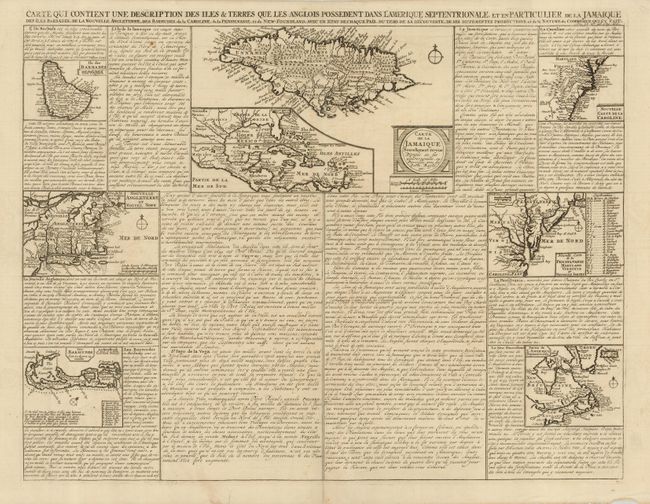
“Carte qui contient une description des Iles & Terres qui les Anglois possedent dans l'Amerique Septentrionale, et en Particulier de la Jamaique…”
Map Maker:
Henry Abraham Chatelain
A very interesting folio sheet containing seven ma... (full text available to subscribers)
| Item Detail |
| |
| |
MapMaker: |
Henry Abraham Chatelain
|
|
| |
| |
Subject: |
Colonial North America, Caribbean & Bermuda |
|
| |
Period/Size: |
1710 / 16.0" x 20.5" (40.7 x 52.1 cm)
|
|
| |
Color: |
Black & White
|
|
| |
Condition: |
(A) One small spot in text area, and a couple short edge splits. Lower portion of centerfold reinforced with tissue. (condition help) |
|
| |
Source: |
|
|
| |
References: |
|
|
| |
|
|
| Sales Information |
| |
| |
Price: |
|
|
| |
| |
Offered by: |
Old World Auctions |
|
| |
Catalog: |
Auction No. 120 - Antique Maps, Charts, Atlases & Globes (613) |
|
| |
Lot/Item #: |
115 |
|
| |
| |
Date: |
07/2007
|
|
| |
| |
|
Antique Maps - Valuation and Pricing, Descriptions, Resources |
|
Home |
Information |
Search |
Register |
Contact Us |
Site Map
Americana Exchange, Inc. © 1999 - 2024 Americana Exchange, Inc.. All rights reserved.
OldMaps.com, the OldMaps.com logo and
AMPR are service marks or registered service marks of Americana Exchange, Inc..
|