Title:
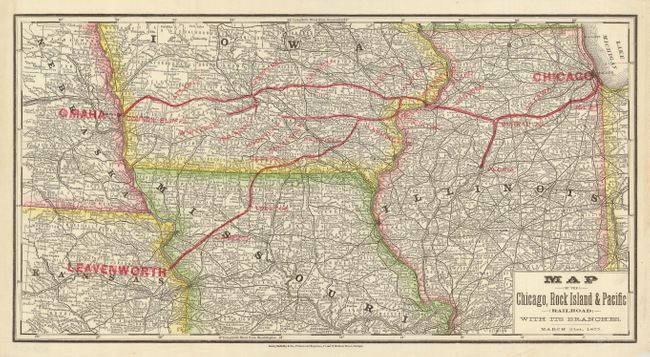
“Map of the Chicago, Rock Island & Pacific Railroad with its Branches.”
Map Maker:
Rand, McNally & Co.
This early Rand McNally map details the route of t... (full text available to subscribers)
| Item Detail |
| |
| |
MapMaker: |
Rand, McNally & Co.
|
|
| |
| |
Subject: |
Central United States |
|
| |
Period/Size: |
1877 / 9.2" x 17.3" (23.4 x 44.0 cm)
|
|
| |
Color: |
Black & White
|
|
| |
Condition: |
(A+) A trace of paste residue at right margin from binding and one light water spot in lower margin, still fine. (condition help) |
|
| |
Source: |
|
|
| |
References: |
|
|
| |
|
|
| Sales Information |
| |
| |
Price: |
|
|
| |
| |
Offered by: |
Old World Auctions |
|
| |
Catalog: |
Auction No. 120 - Antique Maps, Charts, Atlases & Globes (613) |
|
| |
Lot/Item #: |
233 |
|
| |
| |
Date: |
07/2007
|
|
| |
| |
|
Antique Maps - Valuation and Pricing, Descriptions, Resources |
|
Home |
Information |
Search |
Register |
Contact Us |
Site Map
Americana Exchange, Inc. © 1999 - 2024 Americana Exchange, Inc.. All rights reserved.
OldMaps.com, the OldMaps.com logo and
AMPR are service marks or registered service marks of Americana Exchange, Inc..
|