Title:
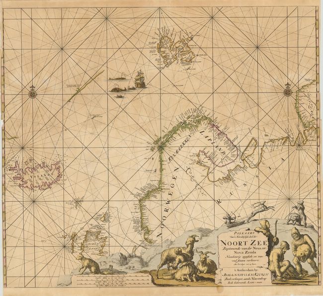
“Paskaart van't Noordelykste deel der Noort Zee Beginnende van der Neus, tot: Nova Zemla…”
Map Maker:
Johannes van Keulen
Scarce sea chart covers Iceland, Spitzbergen, Nova... (full text available to subscribers)
| Item Detail |
| |
| |
MapMaker: |
Johannes van Keulen
|
|
| |
| |
Subject: |
North Atlantic and Arctic Ocean |
|
| |
Period/Size: |
1680 / 20.0" x 22.8" (50.8 x 58.0 cm)
|
|
| |
Color: |
Colored
|
|
| |
Condition: |
(C) Lovely impression with oxidized original color. There are a number of repaired tears in the map, with some chipping and paper weakness, and a small hole on the bottom centerfold. (condition help) |
|
| |
Source: |
|
|
| |
References: |
|
|
| |
|
|
| Sales Information |
| |
| |
Price: |
|
|
| |
| |
Offered by: |
Old World Auctions |
|
| |
Catalog: |
Auction No. 120 - Antique Maps, Charts, Atlases & Globes (613) |
|
| |
Lot/Item #: |
452 |
|
| |
| |
Date: |
07/2007
|
|
| |
| |
|
Antique Maps - Valuation and Pricing, Descriptions, Resources |
|
Home |
Information |
Search |
Register |
Contact Us |
Site Map
Americana Exchange, Inc. © 1999 - 2024 Americana Exchange, Inc.. All rights reserved.
OldMaps.com, the OldMaps.com logo and
AMPR are service marks or registered service marks of Americana Exchange, Inc..
|