Title:
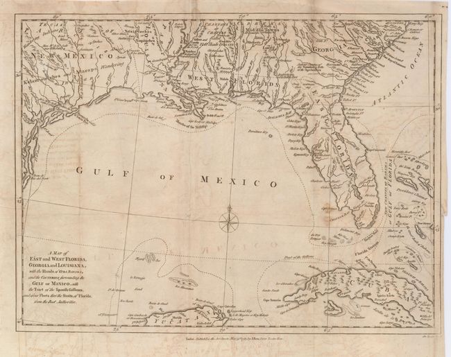
“A Map of East and West Florida, Georgia and Louisiana, with the Islands of Cuba, Bahama, and the Countries Surrounding the Gulf of Mexico, with the Tract of the Spanish Galleons, and of our Fleets thro' the Straits of Florida, from the Best Authorities”
Map Maker:
John Lodge
A crisply engraved map covers the Gulf of Mexico, ... (full text available to subscribers)
| Item Detail |
| |
| |
MapMaker: |
John Lodge
|
|
| |
| |
Subject: |
Gulf of Mexico and Caribbean |
|
| |
Period/Size: |
1781 / 10.5" x 14.0" (26.7 x 35.6 cm)
|
|
| |
Color: |
Black & White
|
|
| |
Condition: |
(B) A sound sheet with some offsetting and a few stains in the map. Close margin at right binding side with a short tear just into the border. (condition help) |
|
| |
Source: |
Political Magazine |
|
| |
References: |
Jolly POL-27; Sellers & Van Ee #1405. |
|
| |
|
|
| Sales Information |
| |
| |
Price: |
|
|
| |
| |
Offered by: |
Old World Auctions |
|
| |
Catalog: |
Auction No. 121 - Antique Maps, Charts, Atlases & Globes (614) |
|
| |
Lot/Item #: |
347 |
|
| |
| |
Date: |
09/2007
|
|
| |
| |
|
Antique Maps - Valuation and Pricing, Descriptions, Resources |
|
Home |
Information |
Search |
Register |
Contact Us |
Site Map
Americana Exchange, Inc. © 1999 - 2024 Americana Exchange, Inc.. All rights reserved.
OldMaps.com, the OldMaps.com logo and
AMPR are service marks or registered service marks of Americana Exchange, Inc..
|