Title:
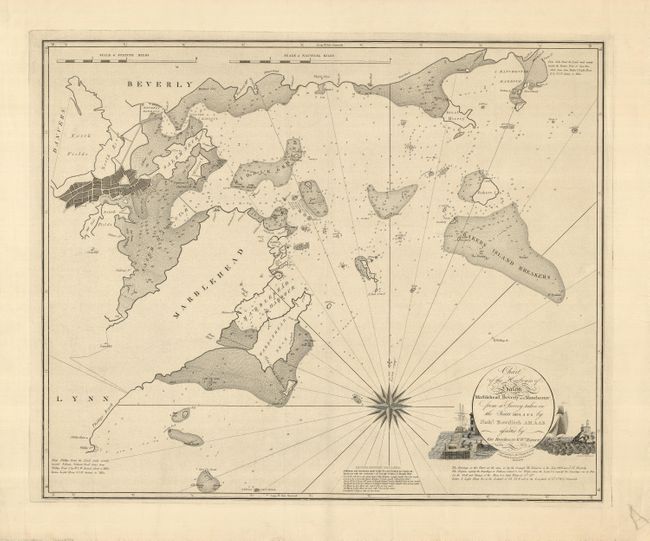
“Chart of the Harbours of Salem, Marblehead, Beverly and Manchester from a Survey taken in the Years 1804, 5 & 6 by Nathl. Bowditch”
Map Maker:
Nathaniel Bowditch
This is an extremely rare, separately issued ma... (full text available to subscribers)
| Item Detail |
| |
| |
MapMaker: |
Nathaniel Bowditch
|
|
| |
| |
Subject: |
Massachusetts, Salem |
|
| |
Period/Size: |
1834 / 21.0" x 26.0" (53.4 x 66.1 cm)
|
|
| |
Color: |
Black & White
|
|
| |
Condition: |
(A) A velvety impression on a thick sheet with some minor creases. The lower right margin has a repaired hole, well away from the map. There are a couple of soft creases and some minor fraying in the margins, which is not uncommon on a separately publis (condition help) |
|
| |
Source: |
|
|
| |
References: |
Guthorn, p.34; Garver (Surveying the Shore), p.51. |
|
| |
|
|
| Sales Information |
| |
| |
Price: |
|
|
| |
| |
Offered by: |
Old World Auctions |
|
| |
Catalog: |
Auction No. 121 - Antique Maps, Charts, Atlases & Globes (614) |
|
| |
Lot/Item #: |
251 |
|
| |
| |
Date: |
09/2007
|
|
| |
| |
|
Antique Maps - Valuation and Pricing, Descriptions, Resources |
|
Home |
Information |
Search |
Register |
Contact Us |
Site Map
Americana Exchange, Inc. © 1999 - 2024 Americana Exchange, Inc.. All rights reserved.
OldMaps.com, the OldMaps.com logo and
AMPR are service marks or registered service marks of Americana Exchange, Inc..
|