Title:
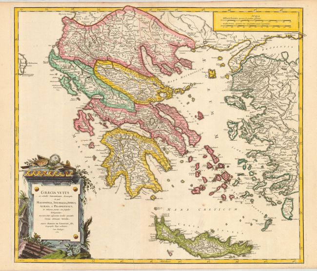
“Graecia Vetus ex Schedis Sansonianis Desumpta in Qua Macedonia, Thessalia, Epiris, Achaia, et Peleponesus… Creta Delineator Insula”
Map Maker:
Robert de Vaugondy [Family]
A large, handsome map of ancient Greece that is ba... (full text available to subscribers)
| Item Detail |
| |
| |
MapMaker: |
Robert de Vaugondy [Family]
|
|
| |
| |
Subject: |
Greece |
|
| |
Period/Size: |
1752 / 19.0" x 21.5" (48.3 x 54.7 cm)
|
|
| |
Color: |
Colored
|
|
| |
Condition: |
(A) A couple spots away from map and two small printers creases. A nice example on fine paper with original margins and large watermark with star and crescent moon and makers name. (condition help) |
|
| |
Source: |
Atlas Universal |
|
| |
References: |
Pedley #369, state 1 |
|
| |
|
|
| Sales Information |
| |
| |
Price: |
|
|
| |
| |
Offered by: |
Old World Auctions |
|
| |
Catalog: |
Auction No. 121 - Antique Maps, Charts, Atlases & Globes (614) |
|
| |
Lot/Item #: |
666 |
|
| |
| |
Date: |
09/2007
|
|
| |
| |
|
Antique Maps - Valuation and Pricing, Descriptions, Resources |
|
Home |
Information |
Search |
Register |
Contact Us |
Site Map
Americana Exchange, Inc. © 1999 - 2024 Americana Exchange, Inc.. All rights reserved.
OldMaps.com, the OldMaps.com logo and
AMPR are service marks or registered service marks of Americana Exchange, Inc..
|