Title:
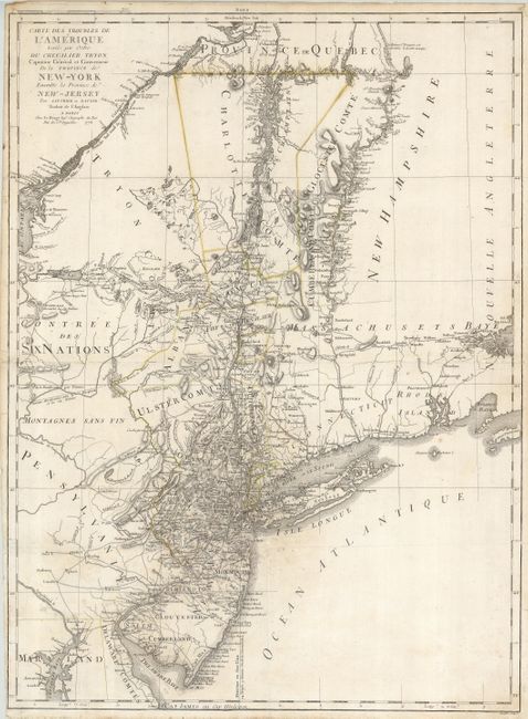
“Carte des Troubles de l'Amerique Levee par Ordre du Chevalier Tryon Capitaine General et Gouverneur de la Province de New-York Ensemble la Province New-Jersey”
Map Maker:
George Louis Le Rouge
A detailed, Revolutionary War map describes... (full text available to subscribers)
| Item Detail |
| |
| |
MapMaker: |
George Louis Le Rouge
|
|
| |
| |
Subject: |
Colonial New England |
|
| |
Period/Size: |
1778 / 28.0" x 20.5" (71.2 x 52.1 cm)
|
|
| |
Color: |
Colored
|
|
| |
Condition: |
(C) A dark impression with remnants of the original outline color. There is an area of mildew centered on Staten Island. The centerfold is weak and has been reinforced, but it would benefit from further reinforcement. A few spots of foxing, close binde (condition help) |
|
| |
Source: |
Atlas Ameriquain Septentrionale |
|
| |
References: |
McCorkle #778.18. |
|
| |
|
|
| Sales Information |
| |
| |
Price: |
|
|
| |
| |
Offered by: |
Old World Auctions |
|
| |
Catalog: |
Auction No. 121 - Antique Maps, Charts, Atlases & Globes (614) |
|
| |
Lot/Item #: |
168 |
|
| |
| |
Date: |
09/2007
|
|
| |
| |
|
Antique Maps - Valuation and Pricing, Descriptions, Resources |
|
Home |
Information |
Search |
Register |
Contact Us |
Site Map
Americana Exchange, Inc. © 1999 - 2024 Americana Exchange, Inc.. All rights reserved.
OldMaps.com, the OldMaps.com logo and
AMPR are service marks or registered service marks of Americana Exchange, Inc..
|