Title:
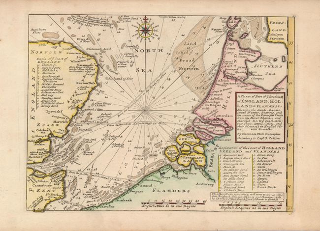
“A Chart of Part of ye Sea Coast of England, Holland & Flanders &c. Shewing the Sands, Banks, Depth of Water, Bearing, and the Course of the Principal Tracts from the River Thames, and Harwich, &c. …”
Map Maker:
Herman Moll
A nicely detailed chart showing the English Channe... (full text available to subscribers)
| Item Detail |
| |
| |
MapMaker: |
Herman Moll
|
|
| |
| |
Subject: |
Europe - Northern |
|
| |
Period/Size: |
1740 / 7.8" x 10.7" (19.9 x 27.2 cm)
|
|
| |
Color: |
Colored
|
|
| |
Condition: |
(A) A strong sheet with a minor repair in the left margin, not affecting the map. (condition help) |
|
| |
Source: |
|
|
| |
References: |
|
|
| |
|
|
| Sales Information |
| |
| |
Price: |
|
|
| |
| |
Offered by: |
Old World Auctions |
|
| |
Catalog: |
Auction No. 121 - Antique Maps, Charts, Atlases & Globes (614) |
|
| |
Lot/Item #: |
463 |
|
| |
| |
Date: |
09/2007
|
|
| |
| |
|
Antique Maps - Valuation and Pricing, Descriptions, Resources |
|
Home |
Information |
Search |
Register |
Contact Us |
Site Map
Americana Exchange, Inc. © 1999 - 2024 Americana Exchange, Inc.. All rights reserved.
OldMaps.com, the OldMaps.com logo and
AMPR are service marks or registered service marks of Americana Exchange, Inc..
|