Title:
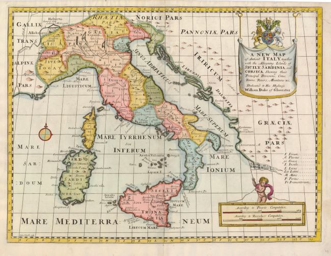
“A New Map of Antient Italy, together with the Adjoyning Islands of Sicily, Sardina, and Corsica, Shewing their Principal Divisions, Cities, Towns, Rivers, Mountains, &c.”
Map Maker:
Edward Wells
Richly colored map that illustrates the historical... (full text available to subscribers)
| Item Detail |
| |
| |
MapMaker: |
Edward Wells
|
|
| |
| |
Subject: |
Italy |
|
| |
Period/Size: |
1700 / 14.5" x 19.3" (36.9 x 49.1 cm)
|
|
| |
Color: |
Colored
|
|
| |
Condition: |
(+B) A dark impression on a sheet with a couple tiny wormholes and a repaired tear that just touches the upper right hand border. (condition help) |
|
| |
Source: |
|
|
| |
References: |
|
|
| |
|
|
| Sales Information |
| |
| |
Price: |
|
|
| |
| |
Offered by: |
Old World Auctions |
|
| |
Catalog: |
Auction No. 122 - Antique Maps, Charts, Atlases & Globes (615) |
|
| |
Lot/Item #: |
653 |
|
| |
| |
Date: |
12/2007
|
|
| |
| |
|
Antique Maps - Valuation and Pricing, Descriptions, Resources |
|
Home |
Information |
Search |
Register |
Contact Us |
Site Map
Americana Exchange, Inc. © 1999 - 2024 Americana Exchange, Inc.. All rights reserved.
OldMaps.com, the OldMaps.com logo and
AMPR are service marks or registered service marks of Americana Exchange, Inc..
|