Title:
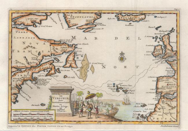
“'T Noorder Gedeelte van Virginie, door Bartholomeus Gosnol en Martin Pringe uyt Engeland bevaaren”
Map Maker:
Pieter van der Aa
This interesting map of the North Atlantic shows p... (full text available to subscribers)
| Item Detail |
| |
| |
MapMaker: |
Pieter van der Aa
|
|
| |
| |
Subject: |
North Atlantic Ocean |
|
| |
Period/Size: |
1714 / 6.0" x 8.7" (15.3 x 22.1 cm)
|
|
| |
Color: |
Colored
|
|
| |
Condition: |
(A) Lovely impression on a sound sheet. (condition help) |
|
| |
Source: |
Scheeps-Togt van Martin Pringe |
|
| |
References: |
|
|
| |
|
|
| Sales Information |
| |
| |
Price: |
|
|
| |
| |
Offered by: |
Old World Auctions |
|
| |
Catalog: |
Auction No. 122 - Antique Maps, Charts, Atlases & Globes (615) |
|
| |
Lot/Item #: |
444 |
|
| |
| |
Date: |
12/2007
|
|
| |
| |
|
Antique Maps - Valuation and Pricing, Descriptions, Resources |
|
Home |
Information |
Search |
Register |
Contact Us |
Site Map
Americana Exchange, Inc. © 1999 - 2024 Americana Exchange, Inc.. All rights reserved.
OldMaps.com, the OldMaps.com logo and
AMPR are service marks or registered service marks of Americana Exchange, Inc..
|