Title:
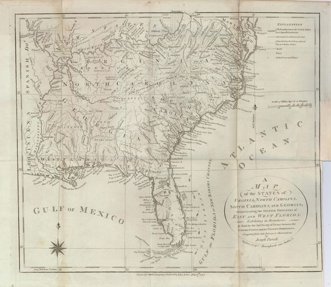
“A Map of the States of Virginia, North Carolina, South Carolina and Georgia; Comprehending the Spanish Provinces of East and West Florida…”
Map Maker:
Joseph Purcell
A very uncommon map of the early Southeast that sh... (full text available to subscribers)
| Item Detail |
| |
| |
MapMaker: |
Joseph Purcell
|
|
| |
| |
Subject: |
Southeast United States |
|
| |
Period/Size: |
1792 / 12.2" x 14.2" (31.0 x 36.1 cm)
|
|
| |
Color: |
Black & White
|
|
| |
Condition: |
(B) A dark impression on a sheet with folds as issued and a couple of light stains along folds. The binding trim affects the neatline and leaves 1/16" margin at right. An odl repair of a tiny binding tear replaces part of the binding trim about 205" lon (condition help) |
|
| |
Source: |
Morse's Geography |
|
| |
References: |
Howes #M840; Sellers & Van Ee #1410; Baynton-Williams (TMC) 72, #5 p. 16. |
|
| |
|
|
| Sales Information |
| |
| |
Price: |
|
|
| |
| |
Offered by: |
Old World Auctions |
|
| |
Catalog: |
Auction No. 122 - Antique Maps, Charts, Atlases & Globes (615) |
|
| |
Lot/Item #: |
219 |
|
| |
| |
Date: |
12/2007
|
|
| |
| |
|
Antique Maps - Valuation and Pricing, Descriptions, Resources |
|
Home |
Information |
Search |
Register |
Contact Us |
Site Map
Americana Exchange, Inc. © 1999 - 2024 Americana Exchange, Inc.. All rights reserved.
OldMaps.com, the OldMaps.com logo and
AMPR are service marks or registered service marks of Americana Exchange, Inc..
|