Title:
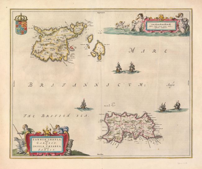
“Sarnia Insula, vulgo Garnsey: et Insula Caesarae, vernacule Jarsey”
Map Maker:
Blaeu [Family]
A beautiful map of the Channel Islands that shows ... (full text available to subscribers)
| Item Detail |
| |
| |
MapMaker: |
Blaeu [Family]
|
|
| |
| |
Subject: |
England, Channel Islands |
|
| |
Period/Size: |
1650 / 15.3" x 18.6" (38.9 x 47.3 cm)
|
|
| |
Color: |
Colored
|
|
| |
Condition: |
(A) A very nice impression with wide original margins. There is a thin area of paper to the upper left of the centerfold, only noticeable when held up to light. (condition help) |
|
| |
Source: |
|
|
| |
References: |
|
|
| |
|
|
| Sales Information |
| |
| |
Price: |
|
|
| |
| |
Offered by: |
Old World Auctions |
|
| |
Catalog: |
Auction No. 122 - Antique Maps, Charts, Atlases & Globes (615) |
|
| |
Lot/Item #: |
466 |
|
| |
| |
Date: |
12/2007
|
|
| |
| |
|
Antique Maps - Valuation and Pricing, Descriptions, Resources |
|
Home |
Information |
Search |
Register |
Contact Us |
Site Map
Americana Exchange, Inc. © 1999 - 2024 Americana Exchange, Inc.. All rights reserved.
OldMaps.com, the OldMaps.com logo and
AMPR are service marks or registered service marks of Americana Exchange, Inc..
|