Title:
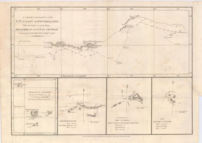
“A Chart Showing Part of the S. W. Coast of New Holland with the Tracks of His Majesty's Sloop Discovery and Armed Tender Chatham Commanded by George Vancouver Esq. in the Year 1791”
Map Maker:
George Vancouver
This crisply engraved chart shows the tracks of Ca... (full text available to subscribers)
| Item Detail |
| |
| |
MapMaker: |
George Vancouver
|
|
| |
| |
Subject: |
Australia |
|
| |
Period/Size: |
1801 / 10.5" x 15.0" (26.7 x 38.1 cm)
|
|
| |
Color: |
Black & White
|
|
| |
Condition: |
(+B) A nice impression on a sheet issued folding, now flattened. There is some scattered foxing in the map, and a repaired binding tear at right that enters the map about 1". (condition help) |
|
| |
Source: |
|
|
| |
References: |
|
|
| |
|
|
| Sales Information |
| |
| |
Price: |
|
|
| |
| |
Offered by: |
Old World Auctions |
|
| |
Catalog: |
Auction No. 122 - Antique Maps, Charts, Atlases & Globes (615) |
|
| |
Lot/Item #: |
819 |
|
| |
| |
Date: |
12/2007
|
|
| |
| |
|
Antique Maps - Valuation and Pricing, Descriptions, Resources |
|
Home |
Information |
Search |
Register |
Contact Us |
Site Map
Americana Exchange, Inc. © 1999 - 2024 Americana Exchange, Inc.. All rights reserved.
OldMaps.com, the OldMaps.com logo and
AMPR are service marks or registered service marks of Americana Exchange, Inc..
|