Title:
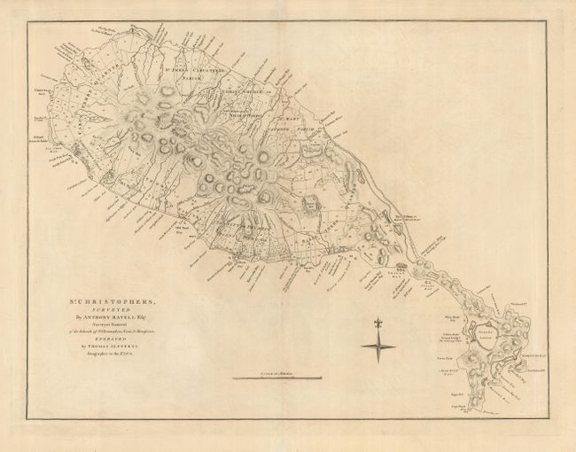
“St. Christophers, Surveyed by Anthony Ravell Esqr. Surveyor General of the Islands of St. Christophers, Nevis, & Montserat”
Map Maker:
Thomas Jefferys
This handsome large-scale map of St. Kitts has num... (full text available to subscribers)
| Item Detail |
| |
| |
MapMaker: |
Thomas Jefferys
|
|
| |
| |
Subject: |
St. Kitts |
|
| |
Period/Size: |
1768 / 18.2" x 24.0" (46.3 x 61.0 cm)
|
|
| |
Color: |
Black & White
|
|
| |
Condition: |
(A) A superb impression on a sheet with a faint trace of offsetting. The margins have some minor tears that have been repaired on the verso with tissue. (condition help) |
|
| |
Source: |
A General Topography of North America |
|
| |
References: |
|
|
| |
|
|
| Sales Information |
| |
| |
Price: |
|
|
| |
| |
Offered by: |
Old World Auctions |
|
| |
Catalog: |
Auction No. 122 - Antique Maps, Charts, Atlases & Globes (615) |
|
| |
Lot/Item #: |
396 |
|
| |
| |
Date: |
12/2007
|
|
| |
| |
|
Antique Maps - Valuation and Pricing, Descriptions, Resources |
|
Home |
Information |
Search |
Register |
Contact Us |
Site Map
Americana Exchange, Inc. © 1999 - 2024 Americana Exchange, Inc.. All rights reserved.
OldMaps.com, the OldMaps.com logo and
AMPR are service marks or registered service marks of Americana Exchange, Inc..
|