Title:
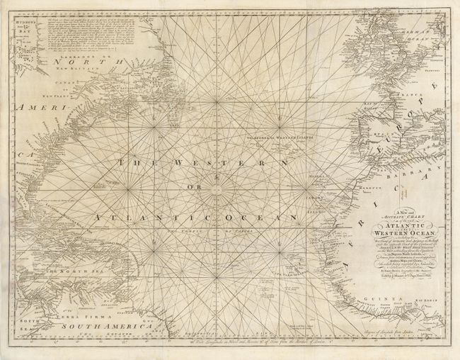
“A New and Accurate Chart of the vast Atlantic or Western Ocean, Including the Sea Coast of Europe and Africa on the East, and the Opposite Coast of the Continent of America & the West India Islands on the West…”
Map Maker:
Emanuel Bowen
A rarely-seen sea chart on two joined sheets detai... (full text available to subscribers)
| Item Detail |
| |
| |
MapMaker: |
Emanuel Bowen
|
|
| |
| |
Subject: |
Atlantic Ocean |
|
| |
Period/Size: |
1774 / 23.5" x 31.3" (59.7 x 79.5 cm)
|
|
| |
Color: |
Black & White
|
|
| |
Condition: |
(B) A few stains, including some on the left part of the map that have been backed with tissue. Still an attractive map on sound paper. (condition help) |
|
| |
Source: |
|
|
| |
References: |
|
|
| |
|
|
| Sales Information |
| |
| |
Price: |
|
|
| |
| |
Offered by: |
Old World Auctions |
|
| |
Catalog: |
Auction No. 122 - Antique Maps, Charts, Atlases & Globes (615) |
|
| |
Lot/Item #: |
434 |
|
| |
| |
Date: |
12/2007
|
|
| |
| |
|
Antique Maps - Valuation and Pricing, Descriptions, Resources |
|
Home |
Information |
Search |
Register |
Contact Us |
Site Map
Americana Exchange, Inc. © 1999 - 2024 Americana Exchange, Inc.. All rights reserved.
OldMaps.com, the OldMaps.com logo and
AMPR are service marks or registered service marks of Americana Exchange, Inc..
|