Title:
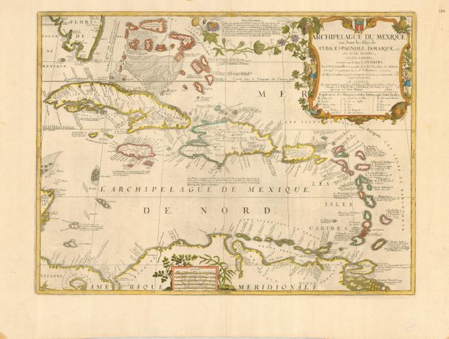
“Archipelague du Mexique, ou Sont les Isles de Cuba, Espagnole, I'Amerique, etc. Avec les Isles Lucayes, et les Isles Caribes, Connues sous le Nom d'Antilles”
Map Maker:
Coronelli/Nolin
This splendid and uncommon map covers all the West... (full text available to subscribers)
| Item Detail |
| |
| |
MapMaker: |
Coronelli/Nolin
|
|
| |
| |
Subject: |
Caribbean |
|
| |
Period/Size: |
1742 / 17.5" x 23.2" (44.5 x 59.0 cm)
|
|
| |
Color: |
Colored
|
|
| |
Condition: |
(A) A clean example on strong paper with an elaborate watermark. The sheet has wide margins, showing a couple minor stains at the lower edges, not affecting the map. (condition help) |
|
| |
Source: |
|
|
| |
References: |
|
|
| |
|
|
| Sales Information |
| |
| |
Price: |
|
|
| |
| |
Offered by: |
Old World Auctions |
|
| |
Catalog: |
Auction No. 122 - Antique Maps, Charts, Atlases & Globes (615) |
|
| |
Lot/Item #: |
375 |
|
| |
| |
Date: |
12/2007
|
|
| |
| |
|
Antique Maps - Valuation and Pricing, Descriptions, Resources |
|
Home |
Information |
Search |
Register |
Contact Us |
Site Map
Americana Exchange, Inc. © 1999 - 2024 Americana Exchange, Inc.. All rights reserved.
OldMaps.com, the OldMaps.com logo and
AMPR are service marks or registered service marks of Americana Exchange, Inc..
|