Rister or Sign In to see pricing information


Title:

Map of the Water Shed and Territory of the Trinity River, Also All of the Railway Lines in the River Belt and Its Vicinity

Map Maker:

U.S. Government

Map of the Water Shed and Territory of the Trinity River, Also All of the Railway Lines in the River Belt and Its Vicinity

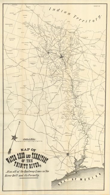
This uncommon sheet shows eastern Texas from India... (full text available to subscribers)
Item Detail
 
  MapMaker:  

U.S. Government


  Subject:  Texas  
  Period/Size:  1900 / 39.0" x 21.0"  (99.1 x 53.4 cm)  
  Color:  Black & White  
  Condition:  (A+) Bright, clean example with the slightest hint of toning at some folds. Folding, as issued. (condition help)  
  Source:  HR Doc. 409, 56th Cong., 1st Sess.  
  References:   
 
 
Sales Information
 
  Price: 

Please register your email to view records, or sign in with email address to see records


  Offered by:  Old World Auctions  
  Catalog:  Auction No. 122 - Antique Maps, Charts, Atlases & Globes (615)  
  Lot/Item #:  337  
 
  Date:  12/2007  


Antique Maps - Valuation and Pricing, Descriptions, Resources


Home | Information | Search | Register | Contact Us | Site Map

Americana Exchange, Inc. © 1999 - 2024 Americana Exchange, Inc.. All rights reserved. OldMaps.com, the OldMaps.com logo and
AMPR are service marks or registered service marks of Americana Exchange, Inc..