Title:
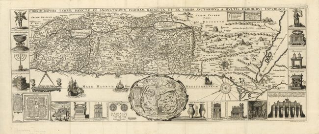
“Chorographia Terrae Sanctae in Angustiorem Formam Redacta, Et Ex Variis Auctoribus Amultis Erroribus Expurgata”
Map Maker:
Jacobus Tirinus
Visually stunning map of the Holy Land surrounded ... (full text available to subscribers)
| Item Detail |
| |
| |
MapMaker: |
Jacobus Tirinus
|
|
| |
| |
Subject: |
Holy Land |
|
| |
Period/Size: |
1632 / 12.5" x 32.3" (31.8 x 82.1 cm)
|
|
| |
Color: |
Black & White
|
|
| |
Condition: |
(B) A nice dark impression on a sheet with a few scattered wormholes. Lower margin with a short tear, not affecting the view. (condition help) |
|
| |
Source: |
|
|
| |
References: |
Laor #771. |
|
| |
|
|
| Sales Information |
| |
| |
Price: |
|
|
| |
| |
Offered by: |
Old World Auctions |
|
| |
Catalog: |
Auction No. 122 - Antique Maps, Charts, Atlases & Globes (615) |
|
| |
Lot/Item #: |
698 |
|
| |
| |
Date: |
12/2007
|
|
| |
| |
|
Antique Maps - Valuation and Pricing, Descriptions, Resources |
|
Home |
Information |
Search |
Register |
Contact Us |
Site Map
Americana Exchange, Inc. © 1999 - 2024 Americana Exchange, Inc.. All rights reserved.
OldMaps.com, the OldMaps.com logo and
AMPR are service marks or registered service marks of Americana Exchange, Inc..
|