Title:
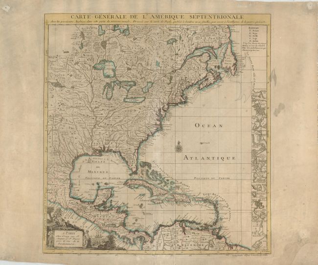
“Carte Generale de l'Amerique Septentrionale avec les Possessions Angloises dans cette partie du nouveau monde, Dresse sur la carte de Pople, publiee a Londres en 20 feuilles, pour servir a l'intelligence de la Guerre Presente.”
Map Maker:
Crepy [Family]
This is the French edition of Popple's key map of ... (full text available to subscribers)
| Item Detail |
| |
| |
MapMaker: |
Crepy [Family]
|
|
| |
| |
Subject: |
Colonial United States and Canada |
|
| |
Period/Size: |
1756 / 20.0" x 19.0" (50.8 x 48.3 cm)
|
|
| |
Color: |
Colored
|
|
| |
Condition: |
(B) A good example that has been backed to repair some tears into the bottom of the map and a missing corner on the lower right blank margin. There are a few stains in the map, mostly confined to the margins. (condition help) |
|
| |
Source: |
|
|
| |
References: |
McCorkle #742.2. |
|
| |
|
|
| Sales Information |
| |
| |
Price: |
|
|
| |
| |
Offered by: |
Old World Auctions |
|
| |
Catalog: |
Auction No. 122 - Antique Maps, Charts, Atlases & Globes (615) |
|
| |
Lot/Item #: |
147 |
|
| |
| |
Date: |
12/2007
|
|
| |
| |
|
Antique Maps - Valuation and Pricing, Descriptions, Resources |
|
Home |
Information |
Search |
Register |
Contact Us |
Site Map
Americana Exchange, Inc. © 1999 - 2024 Americana Exchange, Inc.. All rights reserved.
OldMaps.com, the OldMaps.com logo and
AMPR are service marks or registered service marks of Americana Exchange, Inc..
|