Title:
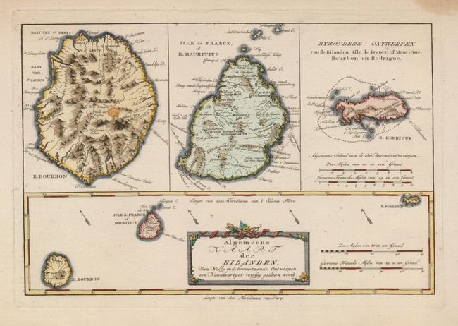
“Algemeene Kaart der Eilanden, van Welke in de Bovenstaande Ontwerpen, een Naaukeuriger Verslag Gedaan Woradt”
Map Maker:
Bonne/Bachiene
This interesting chart covers the islands in the I... (full text available to subscribers)
| Item Detail |
| |
| |
MapMaker: |
Bonne/Bachiene
|
|
| |
| |
Subject: |
Indian Ocean |
|
| |
Period/Size: |
1790 / 8.2" x 12.5" (20.9 x 31.8 cm)
|
|
| |
Color: |
Colored
|
|
| |
Condition: |
(A) There is a small stain in the upper blank margin, well away from the map. (condition help) |
|
| |
Source: |
|
|
| |
References: |
|
|
| |
|
|
| Sales Information |
| |
| |
Price: |
|
|
| |
| |
Offered by: |
Old World Auctions |
|
| |
Catalog: |
Auction No. 122 - Antique Maps, Charts, Atlases & Globes (615) |
|
| |
Lot/Item #: |
808 |
|
| |
| |
Date: |
12/2007
|
|
| |
| |
|
Antique Maps - Valuation and Pricing, Descriptions, Resources |
|
Home |
Information |
Search |
Register |
Contact Us |
Site Map
Americana Exchange, Inc. © 1999 - 2024 Americana Exchange, Inc.. All rights reserved.
OldMaps.com, the OldMaps.com logo and
AMPR are service marks or registered service marks of Americana Exchange, Inc..
|