Title:
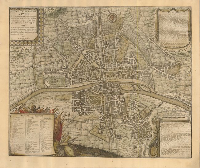
“Sixieme Plan de la Ville de Paris, et ses Accroissements, depuis le commencement du Regne de Charles VII, l'an 1422, jusqu'a la fin Regne d'Henry III l'an 1589”
Map Maker:
Nicolas de Fer
Very attractive and uncommon plan of the city wit... (full text available to subscribers)
| Item Detail |
| |
| |
MapMaker: |
Nicolas de Fer
|
|
| |
| |
Subject: |
Paris, France |
|
| |
Period/Size: |
1705 / 18.0" x 21.5" (45.8 x 54.7 cm)
|
|
| |
Color: |
Colored
|
|
| |
Condition: |
(+B) A dark impression with faded original color. The sheet has been professionally remargined all round with a few lines of facsimile in the lower neatline. (condition help) |
|
| |
Source: |
Traite de la police |
|
| |
References: |
|
|
| |
|
|
| Sales Information |
| |
| |
Price: |
|
|
| |
| |
Offered by: |
Old World Auctions |
|
| |
Catalog: |
Auction No. 123 - Antique Maps, Charts, Atlases & Globes (652) |
|
| |
Lot/Item #: |
537 |
|
| |
| |
Date: |
02/2008
|
|
| |
| |
|
Antique Maps - Valuation and Pricing, Descriptions, Resources |
|
Home |
Information |
Search |
Register |
Contact Us |
Site Map
Americana Exchange, Inc. © 1999 - 2024 Americana Exchange, Inc.. All rights reserved.
OldMaps.com, the OldMaps.com logo and
AMPR are service marks or registered service marks of Americana Exchange, Inc..
|