Title:
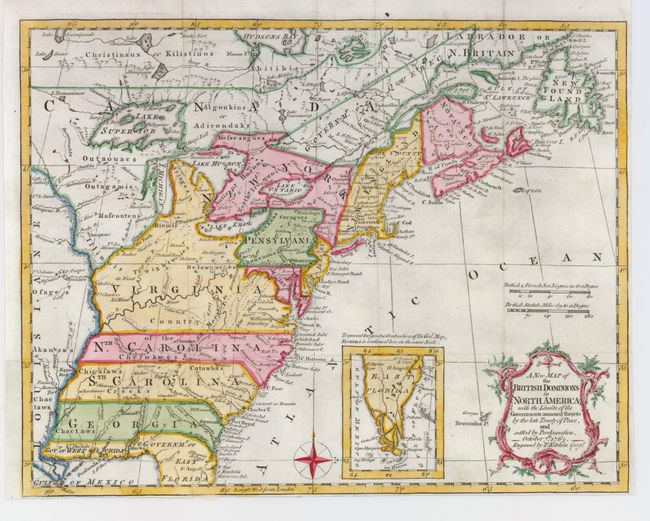
“A New Map of the British Dominions in North America; with the Limits of the Governments annexed thereto by the late Treaty of Peace, and settled by Proclamation, October 7th, 1763”
Map Maker:
Thomas Kitchin
Very historical map illustrates the British coloni... (full text available to subscribers)
| Item Detail |
| |
| |
MapMaker: |
Thomas Kitchin
|
|
| |
| |
Subject: |
Colonial United States and Canada |
|
| |
Period/Size: |
1763 / 9.4" x 11.8" (23.9 x 30.0 cm)
|
|
| |
Color: |
Colored
|
|
| |
Condition: |
(+B) A good impression on a sturdy sheet with margins nearly to the neatline on the right and bottom. Issued folding, now flattened with attractive later color. (condition help) |
|
| |
Source: |
Annual Register |
|
| |
References: |
McCorkle #763.5; Sellers & Van Ee #103; Jolly ANNREG-3. |
|
| |
|
|
| Sales Information |
| |
| |
Price: |
|
|
| |
| |
Offered by: |
Old World Auctions |
|
| |
Catalog: |
Auction No. 123 - Antique Maps, Charts, Atlases & Globes (652) |
|
| |
Lot/Item #: |
140 |
|
| |
| |
Date: |
02/2008
|
|
| |
| |
|
Antique Maps - Valuation and Pricing, Descriptions, Resources |
|
Home |
Information |
Search |
Register |
Contact Us |
Site Map
Americana Exchange, Inc. © 1999 - 2024 Americana Exchange, Inc.. All rights reserved.
OldMaps.com, the OldMaps.com logo and
AMPR are service marks or registered service marks of Americana Exchange, Inc..
|