Title:
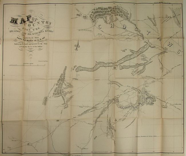
“Map of the Country Upon the Brazos and Big Witchita Rivers Explored in 1854...Embracing the Lands appropriated by the State of Texas for the Use of the Indians”
Map Maker:
U.S. Government
This large and detailed map covers the northeaster... (full text available to subscribers)
| Item Detail |
| |
| |
MapMaker: |
U.S. Government
|
|
| |
| |
Subject: |
Texas |
|
| |
Period/Size: |
1856 / 25.5" x 31.0" (64.8 x 78.8 cm)
|
|
| |
Color: |
Black & White
|
|
| |
Condition: |
(+B) Very nice example of the map that would be fine except for a bit of fold toning at upper right and short closed tear. The report has separated into two parts. (condition help) |
|
| |
Source: |
Senate Doc. 60, 34th Congress 1st Session |
|
| |
References: |
Wagner & Camp #278. |
|
| |
|
|
| Sales Information |
| |
| |
Price: |
|
|
| |
| |
Offered by: |
Old World Auctions |
|
| |
Catalog: |
Auction No. 123 - Antique Maps, Charts, Atlases & Globes (652) |
|
| |
Lot/Item #: |
332 |
|
| |
| |
Date: |
02/2008
|
|
| |
| |
|
Antique Maps - Valuation and Pricing, Descriptions, Resources |
|
Home |
Information |
Search |
Register |
Contact Us |
Site Map
Americana Exchange, Inc. © 1999 - 2024 Americana Exchange, Inc.. All rights reserved.
OldMaps.com, the OldMaps.com logo and
AMPR are service marks or registered service marks of Americana Exchange, Inc..
|