Title:
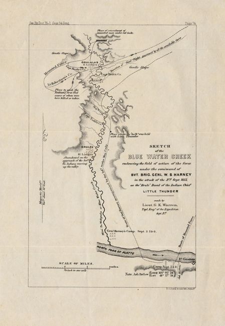
“Sketch of the Blue Water Creek embracing the field of action of the force under the command of Bvt. Brig. Gnl. W. S. Harney in the attack of the 3rd Sept. 1855, on the Brule Band of the Indian Chief Little Thunder”
Map Maker:
U.S. Government
This lithographed map shows the region near presen... (full text available to subscribers)
| Item Detail |
| |
| |
MapMaker: |
U.S. Government
|
|
| |
| |
Subject: |
Nebraska |
|
| |
Period/Size: |
1855 / 8.8" x 5.5" (22.4 x 14.0 cm)
|
|
| |
Color: |
Black & White
|
|
| |
Condition: |
(A) Crisply lithographed with some loss and a small tear in upper, blank margin. The map was issued folding and is now pressed. (condition help) |
|
| |
Source: |
Senate Doc 76, 34th Congress 1st Session |
|
| |
References: |
|
|
| |
|
|
| Sales Information |
| |
| |
Price: |
|
|
| |
| |
Offered by: |
Old World Auctions |
|
| |
Catalog: |
Auction No. 123 - Antique Maps, Charts, Atlases & Globes (652) |
|
| |
Lot/Item #: |
302 |
|
| |
| |
Date: |
02/2008
|
|
| |
| |
|
Antique Maps - Valuation and Pricing, Descriptions, Resources |
|
Home |
Information |
Search |
Register |
Contact Us |
Site Map
Americana Exchange, Inc. © 1999 - 2024 Americana Exchange, Inc.. All rights reserved.
OldMaps.com, the OldMaps.com logo and
AMPR are service marks or registered service marks of Americana Exchange, Inc..
|