Title:
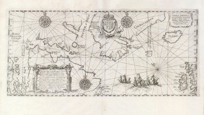
“Tabula Nautica, qua repraesentatur orae maritimae meatus, ac freta, noviter a H Hudsono Anglo ad Caurum supra Novam Franciam indagata Anno 1612”
Map Maker:
Theodore de Bry
This scarce sea chart of the North Atlantic was cr... (full text available to subscribers)
| Item Detail |
| |
| |
MapMaker: |
Theodore de Bry
|
|
| |
| |
Subject: |
Arctic Canada, Greenland and Iceland |
|
| |
Period/Size: |
1613 / 5.8" x 13.1" (14.8 x 33.3 cm)
|
|
| |
Color: |
Black & White
|
|
| |
Condition: |
(A) The map has generous original margins, and it is on a sturdy sheet. There is a little faint foxing, primarily confined to the upper margin. (condition help) |
|
| |
Source: |
|
|
| |
References: |
Burden #165; Kershaw: #55. |
|
| |
|
|
| Sales Information |
| |
| |
Price: |
|
|
| |
| |
Offered by: |
Old World Auctions |
|
| |
Catalog: |
Auction No. 123 - Antique Maps, Charts, Atlases & Globes (652) |
|
| |
Lot/Item #: |
457 |
|
| |
| |
Date: |
02/2008
|
|
| |
| |
|
Antique Maps - Valuation and Pricing, Descriptions, Resources |
|
Home |
Information |
Search |
Register |
Contact Us |
Site Map
Americana Exchange, Inc. © 1999 - 2024 Americana Exchange, Inc.. All rights reserved.
OldMaps.com, the OldMaps.com logo and
AMPR are service marks or registered service marks of Americana Exchange, Inc..
|