Title:
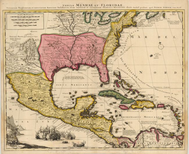
“Tabula Mexicae et Floridae, Terrarum Anglicarum, et Anteriorum Americae Insularum; Item Circum et Circuituum Fluminis Mississipi…”
Map Maker:
Petrus Schenk
This is Schenk's scarce derivative of Guillaume De... (full text available to subscribers)
| Item Detail |
| |
| |
MapMaker: |
Petrus Schenk
|
|
| |
| |
Subject: |
Colonial North America and Caribbean |
|
| |
Period/Size: |
1722 / 19.3" x 24.0" (49.1 x 61.0 cm)
|
|
| |
Color: |
Colored
|
|
| |
Condition: |
(+B) A superb impression with original color. The map has some faint stains in the lower portion of the map. Paper hinge remnants on verso. (condition help) |
|
| |
Source: |
|
|
| |
References: |
Martin & Martin, pl #16. |
|
| |
|
|
| Sales Information |
| |
| |
Price: |
|
|
| |
| |
Offered by: |
Old World Auctions |
|
| |
Catalog: |
Auction No. 123 - Antique Maps, Charts, Atlases & Globes (652) |
|
| |
Lot/Item #: |
122 |
|
| |
| |
Date: |
02/2008
|
|
| |
| |
|
Antique Maps - Valuation and Pricing, Descriptions, Resources |
|
Home |
Information |
Search |
Register |
Contact Us |
Site Map
Americana Exchange, Inc. © 1999 - 2024 Americana Exchange, Inc.. All rights reserved.
OldMaps.com, the OldMaps.com logo and
AMPR are service marks or registered service marks of Americana Exchange, Inc..
|