Title:
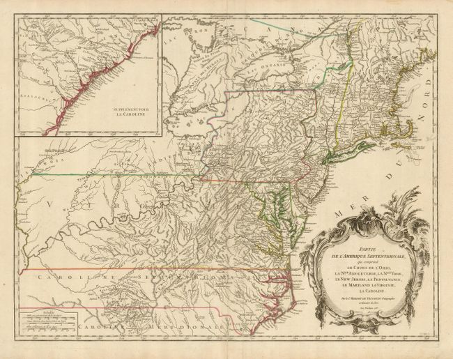
“Partie de l'Amerique Septentrionale, qui Comprend le Cours de l'Ohio, la Nlle. Angleterre, la Nlle. York, le New Jersey, La Pensylvanie, le Maryland la Virginie, la Caroline”
Map Maker:
Robert de Vaugondy [Family]
Beautifully engraved, large map of the eastern sea... (full text available to subscribers)
| Item Detail |
| |
| |
MapMaker: |
Robert de Vaugondy [Family]
|
|
| |
| |
Subject: |
Colonial United States |
|
| |
Period/Size: |
1755 / 19.0" x 25.0" (48.3 x 63.5 cm)
|
|
| |
Color: |
Colored
|
|
| |
Condition: |
(+B) A sharp impression on a sheet with a minor crease along the right side. The centerfold has been reinforced with paper on the verso. Original outline color. (condition help) |
|
| |
Source: |
Atlas Universel |
|
| |
References: |
Cumming (SE) #295; McCorkle #755-37; Pedley #469; Sellers & Van Ee #718. |
|
| |
|
|
| Sales Information |
| |
| |
Price: |
|
|
| |
| |
Offered by: |
Old World Auctions |
|
| |
Catalog: |
Auction No. 123 - Antique Maps, Charts, Atlases & Globes (652) |
|
| |
Lot/Item #: |
167 |
|
| |
| |
Date: |
02/2008
|
|
| |
| |
|
Antique Maps - Valuation and Pricing, Descriptions, Resources |
|
Home |
Information |
Search |
Register |
Contact Us |
Site Map
Americana Exchange, Inc. © 1999 - 2024 Americana Exchange, Inc.. All rights reserved.
OldMaps.com, the OldMaps.com logo and
AMPR are service marks or registered service marks of Americana Exchange, Inc..
|