Title:
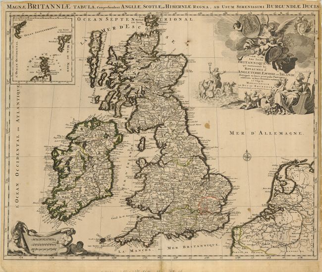
“Les Isles Britanniques qui contiennent les Royaumes d'Angleterre, Escosse, et Irlande…”
Map Maker:
Sanson/Jaillot
A decorative map of the British Isles that feature... (full text available to subscribers)
| Item Detail |
| |
| |
MapMaker: |
Sanson/Jaillot
|
|
| |
| |
Subject: |
Britain |
|
| |
Period/Size: |
1696 / 19.0" x 23.5" (48.3 x 59.7 cm)
|
|
| |
Color: |
Colored
|
|
| |
Condition: |
(B) The map has a few spots, and there are paper repairs at right and left margins and along lower centerfold to close a split. Close margins (1/4") at sides. (condition help) |
|
| |
Source: |
Atlas nouveau… |
|
| |
References: |
Phillips (A) #5953-15. |
|
| |
|
|
| Sales Information |
| |
| |
Price: |
|
|
| |
| |
Offered by: |
Old World Auctions |
|
| |
Catalog: |
Auction No. 124 - Antique Maps, Charts, Atlases & Globes (653) |
|
| |
Lot/Item #: |
405 |
|
| |
| |
Date: |
05/2008
|
|
| |
| |
|
Antique Maps - Valuation and Pricing, Descriptions, Resources |
|
Home |
Information |
Search |
Register |
Contact Us |
Site Map
Americana Exchange, Inc. © 1999 - 2024 Americana Exchange, Inc.. All rights reserved.
OldMaps.com, the OldMaps.com logo and
AMPR are service marks or registered service marks of Americana Exchange, Inc..
|