Title:
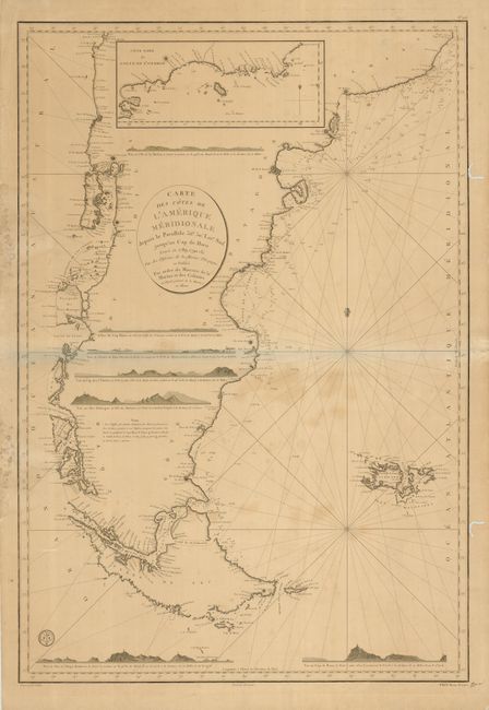
“Carte des Cotes de l'Amerique Meridionale depuis le Parallele 56°30' Late. Sud jusqu'au Cap de Horn Levee en 1789, 1790 &c.”
Map Maker:
Depot de la Marine
An uncommon, large sea chart encompassing the sout... (full text available to subscribers)
| Item Detail |
| |
| |
MapMaker: |
Depot de la Marine
|
|
| |
| |
Subject: |
South America - Southern |
|
| |
Period/Size: |
1800 / 35.6" x 24.5" (90.5 x 62.3 cm)
|
|
| |
Color: |
Black & White
|
|
| |
Condition: |
(B) A good impression with some spots of irregular toning in the map. There is some old mildew, tears and worm tracks in the margins, with some just touching the border. (condition help) |
|
| |
Source: |
|
|
| |
References: |
|
|
| |
|
|
| Sales Information |
| |
| |
Price: |
|
|
| |
| |
Offered by: |
Old World Auctions |
|
| |
Catalog: |
Auction No. 124 - Antique Maps, Charts, Atlases & Globes (653) |
|
| |
Lot/Item #: |
388 |
|
| |
| |
Date: |
05/2008
|
|
| |
| |
|
Antique Maps - Valuation and Pricing, Descriptions, Resources |
|
Home |
Information |
Search |
Register |
Contact Us |
Site Map
Americana Exchange, Inc. © 1999 - 2024 Americana Exchange, Inc.. All rights reserved.
OldMaps.com, the OldMaps.com logo and
AMPR are service marks or registered service marks of Americana Exchange, Inc..
|