Title:
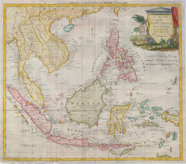
“A Map of the East India Islands, Agreeable to the Most Approved Maps and Charts”
Map Maker:
Thomas Kitchin
An uncommon map covering from Thailand to Papua Ne... (full text available to subscribers)
| Item Detail |
| |
| |
MapMaker: |
Thomas Kitchin
|
|
| |
| |
Subject: |
Southeast Asia |
|
| |
Period/Size: |
1770 / 12.8" x 14.8" (32.6 x 37.6 cm)
|
|
| |
Color: |
Colored
|
|
| |
Condition: |
(+B) Issued folding, now professionally pressed and backed with fine Japanese tissue to repair some small tears at the map edges and a small hole just below the compass rose. Some lines remain from old creases in the piece. (condition help) |
|
| |
Source: |
Millar's New Complete & Universal System of Geography |
|
| |
References: |
|
|
| |
|
|
| Sales Information |
| |
| |
Price: |
|
|
| |
| |
Offered by: |
Old World Auctions |
|
| |
Catalog: |
Auction No. 124 - Antique Maps, Charts, Atlases & Globes (653) |
|
| |
Lot/Item #: |
666 |
|
| |
| |
Date: |
05/2008
|
|
| |
| |
|
Antique Maps - Valuation and Pricing, Descriptions, Resources |
|
Home |
Information |
Search |
Register |
Contact Us |
Site Map
Americana Exchange, Inc. © 1999 - 2024 Americana Exchange, Inc.. All rights reserved.
OldMaps.com, the OldMaps.com logo and
AMPR are service marks or registered service marks of Americana Exchange, Inc..
|