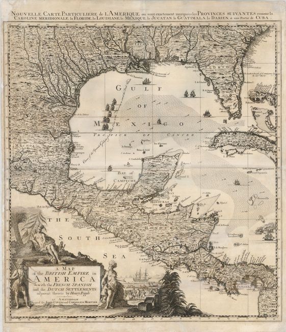
Title:
“A Map of the British Empire in America with the French, Spanish and the Dutch Settlements Adjacent thereto”
Map Maker:
Popple/Covens & Mortier
This is the lower left sheet of Covens & Mortiers ... (full text available to subscribers)
| Item Detail |
| |
| |
MapMaker: |
Popple/Covens & Mortier
|
|
| |
| |
Subject: |
Gulf of Mexico |
|
| |
Period/Size: |
1742 / 23.5" x 20.8" (59.7 x 52.9 cm)
|
|
| |
Color: |
Black & White
|
|
| |
Condition: |
(B) A good impression on a sheet with a miss-fold resulting in a crease in the center. There is a repaired tear in the bottom of the map that enters 2" into the map and one on the left portion of the centerfold that enters about 1.5" into the map. A few (condition help) |
|
| |
Source: |
|
|
| |
References: |
cf Cumming (SE) #231; McCorkle #741.2. |
|
| |
|
|
| Sales Information |
| |
| |
Price: |
|
|
| |
| |
Offered by: |
Old World Auctions |
|
| |
Catalog: |
Auction No. 124 - Antique Maps, Charts, Atlases & Globes (653) |
|
| |
Lot/Item #: |
327 |
|
| |
| |
Date: |
05/2008
|
|
| |
| |
|
Antique Maps - Valuation and Pricing, Descriptions, Resources |
|
Home |
Information |
Search |
Register |
Contact Us |
Site Map
Americana Exchange, Inc. © 1999 - 2024 Americana Exchange, Inc.. All rights reserved.
OldMaps.com, the OldMaps.com logo and
AMPR are service marks or registered service marks of Americana Exchange, Inc..
|