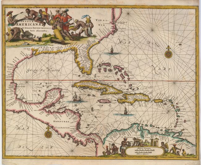
Title:
“Insulae Americanae in Oceano Septentrionali, cum Terris Adiacentibus”
Map Maker:
Arnoldus Montanus
This is the first edition of this outstanding map ... (full text available to subscribers)
| Item Detail |
| |
| |
MapMaker: |
Arnoldus Montanus
|
|
| |
| |
Subject: |
Gulf of Mexico and Caribbean |
|
| |
Period/Size: |
1671 / 11.2" x 14.2" (28.5 x 36.1 cm)
|
|
| |
Color: |
Colored
|
|
| |
Condition: |
(+B) A nice impression with narrow margins touching the neatline on the right and left as is typical of this issue. Faint damp stain in lower margin, not affecting the map. Hinge remnants on verso. (condition help) |
|
| |
Source: |
De Nieuwe en Onbekende Weereldģ |
|
| |
References: |
Burden (II) #414. |
|
| |
|
|
| Sales Information |
| |
| |
Price: |
|
|
| |
| |
Offered by: |
Old World Auctions |
|
| |
Catalog: |
Auction No. 124 - Antique Maps, Charts, Atlases & Globes (653) |
|
| |
Lot/Item #: |
324 |
|
| |
| |
Date: |
05/2008
|
|
| |
| |
|
Antique Maps - Valuation and Pricing, Descriptions, Resources |
|
Home |
Information |
Search |
Register |
Contact Us |
Site Map
Americana Exchange, Inc. © 1999 - 2024 Americana Exchange, Inc.. All rights reserved.
OldMaps.com, the OldMaps.com logo and
AMPR are service marks or registered service marks of Americana Exchange, Inc..
|