Title:
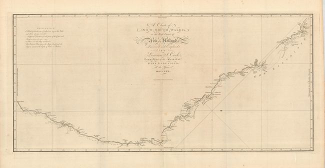
“A Chart of New South Wales, or the East Coast of New Holland. Discovered and Explored by Lieutenant J. Cook, Commander of his Majesty's Bark Endeavor, in the Year MDCCLXX”
Map Maker:
James Cook
This is the first published chart of the east coas... (full text available to subscribers)
| Item Detail |
| |
| |
MapMaker: |
James Cook
|
|
| |
| |
Subject: |
Australia |
|
| |
Period/Size: |
1773 / 14.3" x 30.8" (36.4 x 78.3 cm)
|
|
| |
Color: |
Black & White
|
|
| |
Condition: |
(+B) A sound example with folds as issued, and one intersectional separation reinforced on the verso with tissue. There is a faint spot in the lower part of the map. (condition help) |
|
| |
Source: |
Account of the Voyages Undertaken ... in the Southern Ocean |
|
| |
References: |
Tooley (MCC-64) #325. |
|
| |
|
|
| Sales Information |
| |
| |
Price: |
|
|
| |
| |
Offered by: |
Old World Auctions |
|
| |
Catalog: |
Auction No. 124 - Antique Maps, Charts, Atlases & Globes (653) |
|
| |
Lot/Item #: |
712 |
|
| |
| |
Date: |
05/2008
|
|
| |
| |
|
Antique Maps - Valuation and Pricing, Descriptions, Resources |
|
Home |
Information |
Search |
Register |
Contact Us |
Site Map
Americana Exchange, Inc. © 1999 - 2024 Americana Exchange, Inc.. All rights reserved.
OldMaps.com, the OldMaps.com logo and
AMPR are service marks or registered service marks of Americana Exchange, Inc..
|