Title:
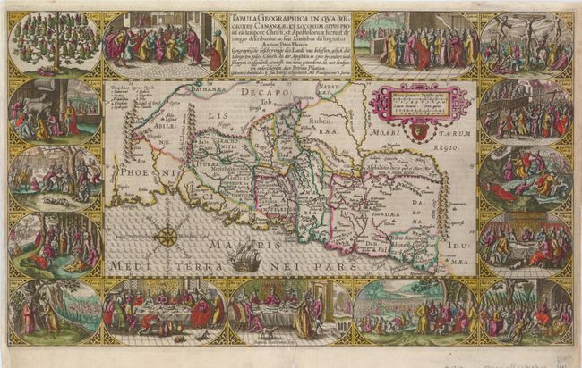
“Tabula Geographica In Qua Regiones Cananaeae. et Locorum Situs Prout ea tempore Christi, et Apostolorum suerunt de integro describuntur, ac suis Limitibus distinguntur Auctore Petro Plancio”
Map Maker:
Plancius/Cloppenburg
A superb and graphic map from a Dutch Bible depict... (full text available to subscribers)
| Item Detail |
| |
| |
MapMaker: |
Plancius/Cloppenburg
|
|
| |
| |
Subject: |
Holy Land |
|
| |
Period/Size: |
1643 / 11.5" x 19.5" (29.3 x 49.6 cm)
|
|
| |
Color: |
Colored
|
|
| |
Condition: |
(+B) Expert repairs on centerfold and a couple of tears into map near the centerfold, with the margin extended at left, all very professionally accomplished. (condition help) |
|
| |
Source: |
|
|
| |
References: |
Laor #569; Poortman & Augusteijn #80. |
|
| |
|
|
| Sales Information |
| |
| |
Price: |
|
|
| |
| |
Offered by: |
Old World Auctions |
|
| |
Catalog: |
Auction No. 125 - Antique Maps, Charts, Atlases & Globes (654) |
|
| |
Lot/Item #: |
722 |
|
| |
| |
Date: |
09/2008
|
|
| |
| |
|
Antique Maps - Valuation and Pricing, Descriptions, Resources |
|
Home |
Information |
Search |
Register |
Contact Us |
Site Map
Americana Exchange, Inc. © 1999 - 2024 Americana Exchange, Inc.. All rights reserved.
OldMaps.com, the OldMaps.com logo and
AMPR are service marks or registered service marks of Americana Exchange, Inc..
|